Watershed Special Characteristics or Features
Four Mile Run flows through residential areas as well as urban corridors in south and western Arlington. Four Mile Run is the largest stream flowing through Arlington, draining approximately two-thirds of the County.

Drainage area of the Barcroft monitoring site. This area also encompasses the other Four Mile Run monitoring sites of Banneker, Bluemont and Glencarlyn, Source: arlingtonva.us
Climate
The Four Mile Run watershed straddles the Mid-Atlantic piedmont and coastal plain physiographic provinces approximately 50 miles east of the Blue Ridge Mountains, and 35 miles west of the Chesapeake Bay. Watershed elevations range from sea level to 425 feet above mean sea level. Four Mile Run is a tributary of the Potomac River, and enters the river on its western shore at the southern end of Ronald Reagan National Airport (formerly Washington National Airport). Precipitation is generally evenly distributed throughout the year, with an annual rainfall of 39 inches per year. Snowfalls average 18 inches per year, with perhaps only one or two major snowfalls in a season.
Land Use
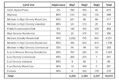
The non-tidal portion of the Four Mile Run watershed is 10,874 acres, or 17.0 square miles.
Table below shows the acreage of each existing land use in the impaired portion of the watershed and the average estimated impervious land use. Using this table yields an overall imperviousness for the impaired portion of the watershed of 41.5%.
Bacteria Source Tracking
A study by the Northern Virginia Regional Commission (NVRC) examined the sources of the bacteria, showing the major sources of identifiable bacteria were urban wildlife (waterfowl and raccoons), humans and dogs. A Total Maximum Daily Load (TMDL) has been created for Four Mile Run, and a management strategy for controlling anthropogenic sources of bacteria to the stream has been created.

Across Arlington, our volunteer monitoring data shows that bacteria levels are highest:
- · During warm months (May to October)
- · During and 24-48 hours after rainstorms.
Those are the conditions that we tend to see peaks in bacteria levels and the most exceedances of water quality standards.


The four mile run bacteria source map shows that there are three bacteria monitoring sites on Lubber Run; two in Woodlawn Park and one in Lubber Run Park, while Doctor’s branch watershed has one in Alcova Heights Park and one in Barcroft Park. More than 80 percent of Doctor’s Branch was found to be in stabilizing condition. These results in graph are averages of E. coli levels from 4-6 sites in each group. The orange line is the secondary water quality standard (for touching the water). The teal line is the primary water quality standard (for swimming).
- · Four Mile Run Tributaries: Second lowest bacteria levels
Sites include Lubber Run, Upper Long Branch, Doctor’s Branch and Lower Long Branch.
Macroinvertebrate Monitoring Data
Lubber Run, which is located in a central part of the four mile run watershed, is a comparatively new macroinvertebrate monitoring site, with data first collected in 2010. The monitoring site is located in Lubber Run Park near the intersection of Fourth Street North and North Edison Street.
Macroinvertebrates commonly found are:
- · Aquatic worms
- · Flatworms
- · Midges
- · Net-spinning caddisflies
- · Small minnow mayflies
Macroinvertebrates in Media
To find out more about the Macroinvertebrates monitoring in Arlington click on these links:
https://environment.arlingtonva.us/streams/macroinvertebrates/
https://www.youtube.com/watch?v=9gp03sxR1Nw&feature=youtu.be


Raena - we have some of the same issues on my side of the river in the Cabin John Creek Watershed. I do water quality monitoring and we have lost the diversification of macroinvertebrates there. Sewer overflow, dogs and deer elevate our bacteria levels too.
ReplyDeleteThanks for the info!